- 24 August 2017
- From the sectionScience & Environment
Kijun Times
Walking in Shackleton's footsteps |
|||||
|---|---|---|---|---|---|
| 이름 | 윤소연 | 등록일 | 17.09.15 | 조회수 | 673 |
Walking in Shackleton's footsteps 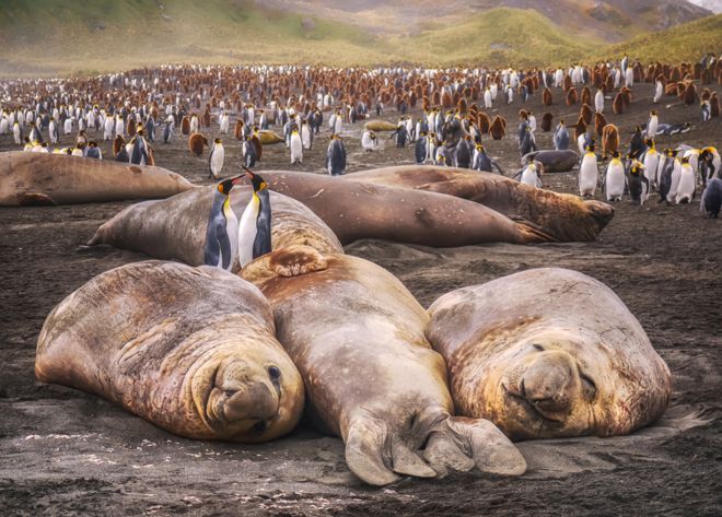 GETTY IMAGES GETTY IMAGESShackleton's escape from the Antarctic in 1916 is well told. It is without doubt a remarkable story given the many challenges he and his crew had to overcome after losing their ship, the Endurance. For months they drifted on sea-ice, before making a lifeboat dash to Elephant Island, followed by a hazardous sail across the Southern Ocean to South Georgia. And if that wasn't enough, Shackleton and two colleagues then trekked over the mountains and ice fields of the British Overseas Territory to a whaling station to get help for the men stranded further back along the escape route. Precisely how the explorer accomplished the last leg of the journey, across South Georgia, you can now follow in detail on a new map of the island.
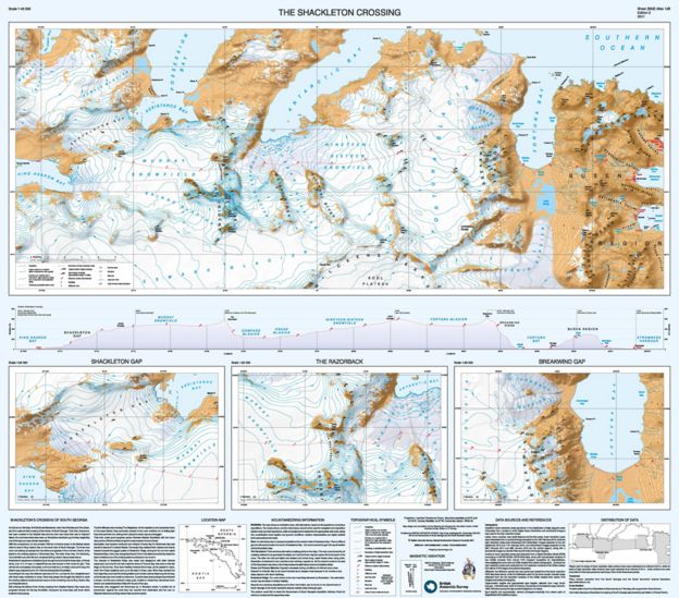 BAS BASThe British Antarctic Survey (BAS) has updated its 1:200,000 rendering of the territory, with a special feature it calls The Shackleton Crossing on the map's B-side. "We've never had a product like this before, and we've put a lot of effort into making it as detailed as possible," explained Laura Gerrish, a BAS mapping specialist. "We've used stereo pairs of very high-resolution imagery to make the elevation data; and we've manually digitised all the rock and ice areas. "We don't intend it as the route you must take, but it does show those who want to recreate the crossing the paths that are available," she told BBC News. 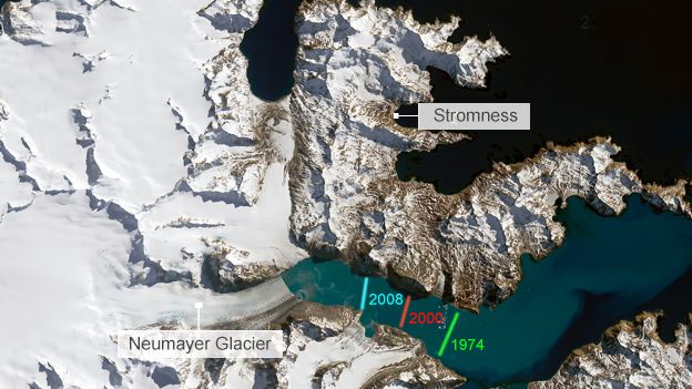 LANDSAT/USGS LANDSAT/USGSThe Shackleton portion of the map is reproduced at 1:40,000 scale, with three insets at 1:25,000. These illustrate the more dangerous parts of the 30km trek*, including The Razorback ridge and Breakwind Gap, which have near-vertical descents. Shackleton, with Tom Crean and Frank Worsley, negotiated these obstacles by tobogganing on their coiled ropes. 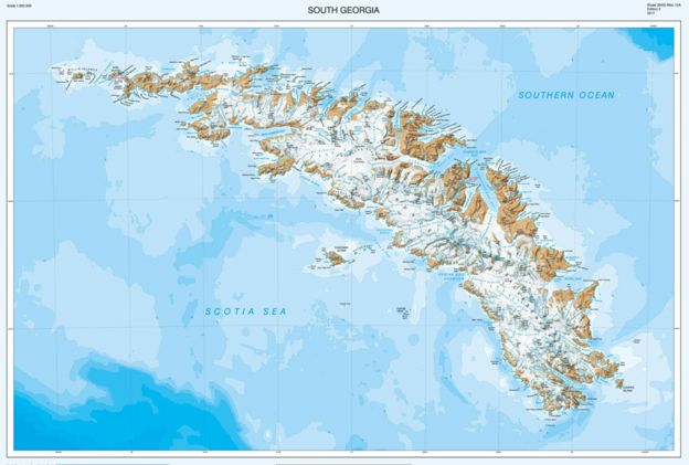 BAS BASIf the trio could retrace their steps today, they would be astonished at the changes that have taken place. South Georgia is warming and its ice fields are in rapid retreat - something that has become very evident since 2004, the last time BAS updated the map. "The data we have now is much more accurate of course, but there are many more new bays, coves, promontories and lakes, simply because the glaciers have retreated so much," Ms Gerrish said. I wrote in March about the glacial history of South Georgia. Some 20,000 years ago, during the last ice age, the island's glaciers pushed out 50km and more from their current positions, reaching to the edge of the continental shelf. |
|||||
| 이전글 | Does the UK need a human 'body farm'? By Prof Sarah Gabbott |
|---|---|
| 다음글 | Why did we use leaded petrol for so long? |